Water management

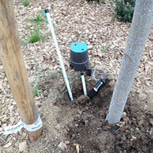
Tensiometry
Water is no longer an environmental actor as it was often discussed and named in the past, and through this misguided vision, has often been mismanaged, poorly considered and therefore poorly conceived. Water is the starting point, the zero element of a landscape project. Without water, there is no life. In excess, a number of disorders can appear, which can lead to the death of certain plants by asphyxiation.
The need to consider water as a limited, exhaustible reserve, implies a method and a system of reasoning that is the opposite of the landscape practices of past centuries, and imposes on landscape thinking and landscape designers, at times, to no longer reason about plants as the central element of a garden, especially plants with shallow roots, but to take into account and use all the vegetative strata, by associating a selection of plants adapted to the place, the project and the style of the chosen garden.
It is therefore necessary to work on the water retention capacity of the soil, to limit its evaporation, while avoiding the creation of reserves or pockets of water on the surface or under layers, which could be detrimental to infrastructures and masonry works, but also to the plant and animal kingdoms.
An analysis of the soil, will make it possible to know its content and to influence its capacity to retain or filter water in these soils. The aim is to simplify and release air/water exchanges, allowing soils to drain and evaporate excess water, while restoring it easily according to the needs of plants, but making the presence of water last as long as possible in the soil.
To help us in our missions and our task, several actors or tools can help us:
- Soil analysis carried out by a professional entity such as the FREDON Ile de France, can help us to know more about the nature of the soil and provide us with valuable advice to influence their improvement and select the right plant species, the right irrigation, measure if necessary by tensiometry probes etc.
- Soil analysis can be done by taking samples from different parts of the area concerned, then putting them in jars with water supply to read the soil layers, and transferring the readings to the texture triangle, which will give us an indication of the type of soil present,
- The realization of a ball of earth will also give us an indication, while taking into account at the time of the realization of the ball, the season and the water conditions.
After determining the soils present, other tools are at our disposal, such as the installation of meteorological stations, coupled with irrigation systems, all integrated into the study project as soon as it is considered, making it possible to make up for water shortages, according to the needs, the nature of the vegetation found in the project and the soils in place. Example: use of cannons, sprinklers, nozzles or in-line drippers for watering plants, if necessary with soil cover management.
In any case: information, awareness and consciousness raising on the part of your interlocutor, sponsor or customer, is essential and necessary through your duty of advice and information, in order to remove any misunderstanding, source of conflict, or even failure of the project, with an awareness of the quantities of watering water involved and the related costs. In case of bad apprehension of all these data, the concretization and the good evolution of the landscaped project could be jeopardized!

